基本介绍(Basic Information)
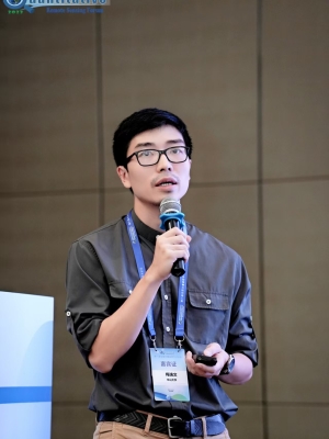
梅逸文(Yiwen Mei, Ivan Mui),博士,副教授,硕士生导师,中山大学“百人计划”引进人才。主要从事水文模拟和流域水文过程等方面的研究。主持广东省面上项目1项,国家重点研发计划子课题1项。曾参与美国宇航局(NASA)高亚洲科学团队、美国地质调查局(USGS)John Wesley Powell分析与综合中心五大湖地下水资源和马来西亚教育部基础研究资助计划等项目。研究成果以第一或通讯作者身份发表在Water Resources Research,Hydrology and Earth System Science,Journal of Hydrology和Journal of Hydrometeorology等国际知名期刊。自2018年起担任水文水资源领域顶刊Journal of Hydrology的副主编。
其它个人网站:ResearchGate; Google Scholar; Academia
Exploration of causality embodies a process of self-redemption that escorts us from the misery of ignorance to the serenity bestowed by knowledge.
By Yiwen Mei, July 14th 2024
研究方向(Research Interest)
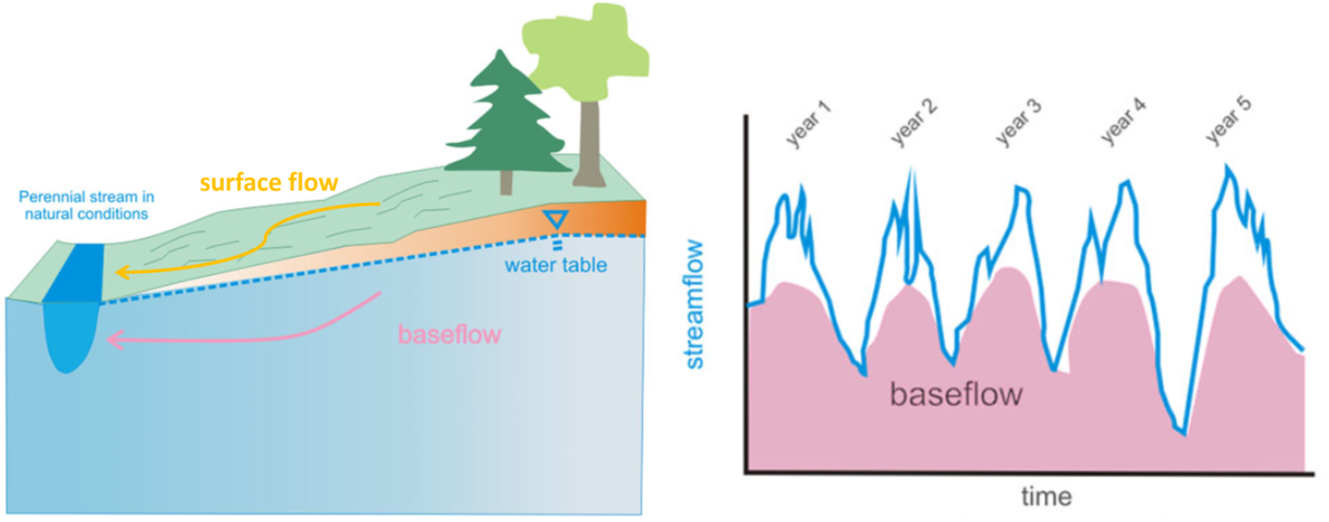
径流组分划分:河流流量一般可分为快速流和慢速流两个组分,其中慢速流通常被称为基流(Baseflow)。基流代表来自地下水或深层土壤水补给的河流流量的稳定部分。通过探究环境示踪剂浓度(如电导率和浊度)与流量之间的关系(即C-Q关系),我们可以准确划分基流在总流量中的占比,从而为有效管理流域水资源、确保生态环境安全提供关键的数据支持。

多目标水文模型优化:水文模型是分析流域内各种水文过程(如径流、蒸散发、下渗等)的有效工具。这些模型包含一些代表流域特定物理特性的待定参数,这些参数通常需要通过使用足够长时间的径流观测数据进行校准,以确保模拟结果的准确性。然而,仅仅基于观测径流进行单一目标的校准,可能会导致“异参同效(Equifinality)”现象,即出现多组参数组合都能产生相似的模拟结果,但其中一些参数的取值可能并不符合物理约束。为了有效解决这一问题,我们可以纳入除径流外的其他水文观测数据(如蒸散发、土壤水分等)进行多目标校准。这样做不仅可以减少“异参同效”现象的发生,还能使水文模型更具物理代表性,从而更好地服务于流域水文模拟实践。

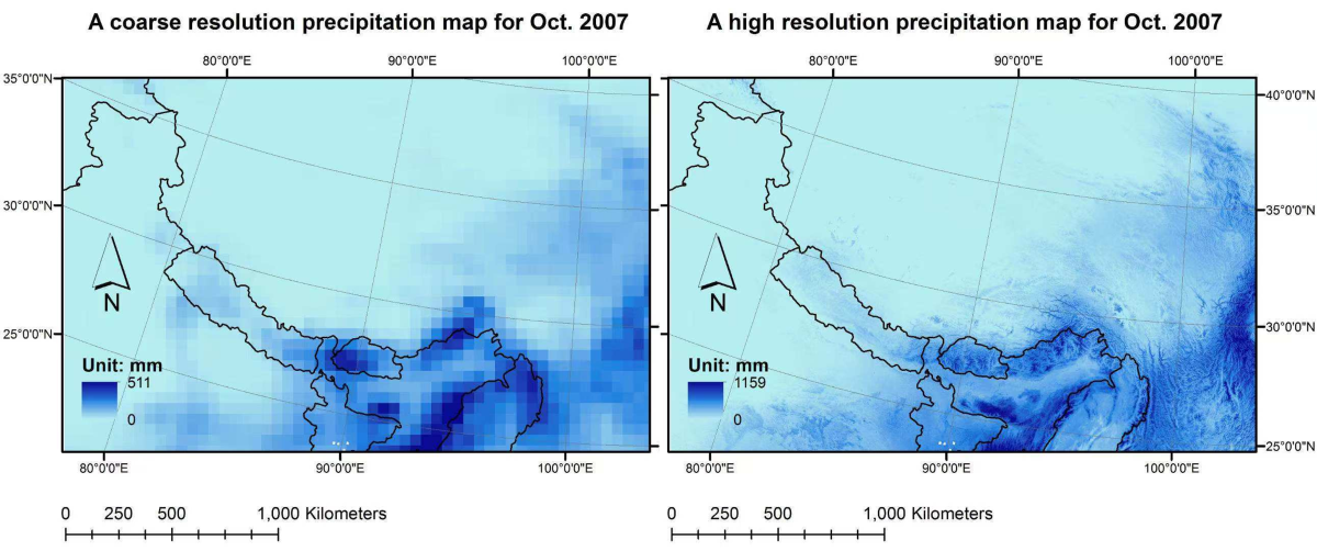
大气变量降尺度与误差修正:一般网格化的气象再分析数据(Climate Reanalysis Data)空间分辨率通常不高于0.1°(约10公里),这使得它们难以准确反映地形对近地面气象条件的复杂调制作用,进而造成山区水文模拟结果的不准确。为了克服这一局限,我们可以结合高分辨率的地形(如高程、坡度等)与地表工况数据(如土地覆盖、植被类型等),并运用物理规律和机器学习算法(Machine Learning),来构建高分辨率的气温、气压、湿度、入射长波辐射、短波辐射、风速和降水数据(分辨率可达1公里或更精细)。这些高分辨率数据将为水文模拟提供更精确的驱动信息,从而提高模拟的准确性。

招生方向(Hiring Information)
种类:硕士-070500地理学,硕士-070501自然地理学,硕士-070503地图学与地理信息系统,硕士-085700资源与环境
品质:有批判性思维(Critical Thinking),对知识充满渴望,对相关研究方向感兴趣,有良好的计划能力,善于沟通合作
技能:水文模型或陆面模式,趋势与归因分析,基本编程技能(如Matlab、Python、R等)
数据产品与代码(Dataset and Code)
- 基于流域特征的区域化基流分割参数集 [Lin, Y., Mei, Y., Wang, D. (2025). Data and code archive for "Regionalization of Optimal Baseflow Separation using Catchment-scale Characteristics", Version 1]
- 基于水量和化学质量双守恒原理的长期逐日基流数据库 [Mei, Y., Zhu, J., Wang, D. (2024). Data and Code Archive for "Optimal Baseflow Separation through Chemical Mass Balance: Comparing the Usages of Two Tracers, Two Concentration Estimation Methods, and Four Baseflow Filters", Version 1]
- 密歇根湖区20个流域的多变量-多目标率定水文模型 [Mei, Y., Reeves, H., Mai, J. (2023). PRMS Model Archive for Selected Catchments in the Lake Michigan Basin Used in Examination of Multi-Objective Model Calibration, Version 1]
- 亚洲高山区2003至2018年1公里6小时分辨率降尺度气象数据集 [Xue, Y., Houser, P. R., Maggioni, V., Mei, Y. (2021). High Mountain Asia 1 km 6-hourly Downscaled Meteorological Data 2003 to 2018, Version 1]
- 其它代码分享:GitHub
学历背景(Education)
- 2012.8–2017.5:哲学博士(Ph.D.),康涅狄格大学(美),环境工程,导师:Emmanouil N. Anagnostou
- 2010.8–2012.8:理学硕士(M.Sc.),康涅狄格大学(美),环境工程,导师:Emmanouil N. Anagnostou
- 2006.9–2010.6:工学学士(B.Eng.),广东工业大学,环境工程
工作经历(Professional Experience)
- 2023.2– 现在:中山大学,地理科学与规划学院国土资源与环境系,副教授
- 2022.1–2023.2:康涅狄格大学(美),康涅狄格复原与气候适应研究所,副研究员,部门主管:James O'Donnell
- 2020.2–2022.1:密歇根大学(美),环境与可持续发展学院,博士后研究员,合作导师:Andrew Gronewold
- 2017.4–2020.1:乔治梅森大学(美),Sid and Reva Dewberry土木、环境与基础设施工程系,博士后研究员,合作导师:Viviana Maggioni、Paul Houser
社会任职(Synergistic Activity)
- 2018.1– 现在:Journal of Hydrology,副主编
- 2021.1–2023.5:Remote Sensing,客座编辑,Flood Vulnerability Assessment with Hydrologic/Hydraulic Modeling and Remote Sensing Techniques
- 2020.5–2021.9:Frontiers in Environmental Science,客座编辑,Rivers, Science, and Society: The Role of Numerical Models, Remote-Sensing, and Citizen-Science in Flood Risk Management
- Water Resources Research、Hydrology and Earth System Science、Journal of Geophysical Research-Atmosphere、Journal of Hydrology、Journal of Hydrometeorology等国际学术期刊的审稿人
- 美国地球物理协会(American Geophysical Union)2022秋季会议Outstanding Student Presentation Awards(OSPA)项目评委
讲授课程(Course)
- GP 112 自然地理学(Physical Geography),大二上,本科专业必修课
- GP 3029E 专业英语(Specialized English),大三下,本科专业选修课
- GP 5710 现代地学模型方法及其应用(Modern Earth Science Modeling Methods and Applications),研一上,研究生专业必修课
学生指导(Student Instructing)
- 周元迪,2023级硕士(预计毕业时间2026年6月),硕士论文题目:基流干旱事件特征的空间分布和历史趋势研究
- 王程宇,2024级硕士(预计毕业时间2027年6月),硕士论文题目:基于动态匹配算法的气象-水文干旱传播机制研究
- 范思源,2025级硕士(预计毕业时间2028年6月),硕士论文题目(暂定):基于示踪剂的季节性基流分割优化
科研项目 (Research Project)
主持或负责人
- 国家重点研发计划重大自然灾害防控与公共安全专项。“极端暴雨洪涝灾害链模拟器实战化应用关键技术:课题二、面向应急实战的暴雨洪涝灾害链全过程智能化模拟推演技术”。课题骨干,项目时间:2025年1月至2027年12月(3年)。
- 广东省基础与应用基础研究基金自然科学基金面上项目。“东江流域基流特征对极端降水和植被变化的响应研究”。主持,项目时间:2025年1月至2027年12月(3年)。
- 中山大学“百人计划”引进人才启动项目。“变化条件下华南地区水力发电量适应性评估”。主持,项目时间:2023年4月至2027年12月(4年)。
- 中山大学科研业务费“青年教师培养”项目。“基于遥感土壤水喝逆向水平衡的降水反演研究”。主持,项目时间:2023年1月至2023年12月(1年)。
合作或参与
- 越南岘港大学Funds for Science and Technology Development。“Development of a drought prediction model using satellite products and a machine learning technique.”。主持:Hưng Thành Phạm,项目时间:2021年5月至2023年8月(2年)。
- 美国地质调查局(USGS)John Wesley Powell Center for Analysis and Synthesis。“Improving representation of groundwater in foundational hydrologic models and data sets across the Laurentian Great Lakes basin.”。主持:Andrew Gronewold,项目时间:2020年9月至2022年8月(2年)。
- 密歇根大学Office for Research, Mcubed program。“Simulating and visualizing foundational basin-scale hydrologic data.”。主持:Andrew Gronewold,项目时间:2020年1月至2020年12月(1年)。
- 马来西亚教育部Fundamental Research Grant Scheme (FRGS 2019)。“Investigating Error Propagation of High-resolution Satellite Precipitation Products-Driven Modeling of Flood Events in Peninsular Malaysia.”。主持:Wan Zurina Wan Jaafar,项目时间:2019年1月至2021年12月(3年)。
- 美国宇航局(NASA)ROSES 2015。A.48 Understanding Changes in High Mountain Asia, “HMA-LDAS: Hyper-Resolution High Mountain Asia - Land Data Assimilation System.”。主持:Paul Houser、Viviana Maggioni,项目时间:2016年8月至2019年7月(3年)。
论著专利(Publication List)
- 学术论文(Journal Article)
- Li, C., Wu, H., Alfieri, L., Mei, Y., Nanding, N., Huang, Z., Hu, Y., Qu, L. (2026). Enhancing Hydrological Model Calibration for Flood Prediction in Dam-Regulated Basins with Satellite-Derived Reservoir Dynamics. Remote Sens. 18(2), 193.
- Liu, Z., Liu, W., Wang, S., Wang, X., Zhu, J.*, Wang, D., Dong, C., Cheng, G., Mei, Y., Qi, X. (2026). Divergent occupational heat stress strategies required for Northern and Southern China under climate change. Int. J. Biometeorol. 70, 6.
- Li, L., Wu, H.*, Jiang, L., Mei, Y., Kimball, J. S., Alfieri, L., Huang, Z., Hu, Y., Chen, S., Dong, S., Hu, Y., and Wu, W. (2025). A hybrid framework for sub-seasonal to seasonal streamflow prediction: integrating numerical and statistical models. npj Clim. Atmos. Sci. 8, 393.
- Lewis, C. H. R., Mei, Y., Voyles, J., Richards-Zawacki, C. L., Batista, A., Belden, L. K., Estrada, A., Hertz, A., Hughey, M. C., Medina, D., Rebollar, E. A., Woodhams, D. C., Flores, E. E., Guerrel, J., Illueca, E., Ibáñez, R., Houser, P., & Gratwick, B.* (2025). Modelling Batrachochytrium dendrobatidis presence and intensity using high spatial and temporal resolution weather data. Divers. Distrib. 31(7), e70052.
- Chen, R., Wang, D.*, Mei, Y., Lin, Y., Lin, Z., Zhang, Z., Zhuang, S., Zhu, J., Kam, J., Wu, Y., & Tang, G. (2025). A knowledge-guided LSTM reservoir outflow model and its application to streamflow simulation in reservoir-regulated basins. J. Hydrol. 657, 133164.
- Zhang, Z., Wang, D.*, Mei, Y., Zhu, J., & Xiao, X. (2025). Developing an explainable deep learning module based on the LSTM framework for flood prediction. Front. Water. 7, 1562842.
- Weng, X., Zhang, H., Zhu, J.*, Wang, D., Wang, S., Mei, Y., & Luo, M. (2025). Unveiling Divergent Trends in Soil Erosion and Soil Organic Carbon Displacement in Response to Climate and Land-Use Changes over China. Earth Interact. 29, e240002.
- Mei, Y., Wang, D.*, Zhu, J., Tang, G., Cai, C., Shen, X., Hong, Y., & Zhang, X. (2024). Optimal Baseflow Separation through Chemical Mass Balance: Comparing the Usages of Two Tracers, Two Concentration Estimation Methods, and Four Baseflow Filters. Water Resour. Res. 60(7), e2023WR036386.
- Zhong, M.*, Xiao, L., Li, X., Mei, Y., Jiang, T., Song, L., & Chen, X. (2024). A study on compound flood prediction and inundation simulation under future scenarios in a coastal city. J. Hydrol. 628, 130475.
- Wang, D., Wang, D.*, Mei, Y., Yang, Q., Ji, M., Li, Y., Liu, S., Li, B., Huang, Y., Mo, C. (2024). Estimates of the land surface hydrology from the Community Land Model version 5 (CLM5) with three meteorological forcing datasets over China. Remote Sens. 16(3), 550.
- Weng, X., Zhu, J.*, Wang, D., Zhong, M., Luo, M., Mei, Y., & Tang, G. (2024). Assessing rainfall erosivity changes over China through a Bayesian averaged ensemble of high-resolution climate models. Environ. Res. Commun. 6(3), 035025.
- Ng, C. Y., Jaafar, W. Z. W.*, Othman, F., Lai, S. H., Mei, Y., & Liew, J. (2024). Assessment of Evaporative Demand Drought Index for Drought Analysis in Peninsular Malaysia, Sci. Total Environ. 917, 170249.
- Mei, Y.*, Mai, J., Do, H. X., Gronewold, A., Reeves, H., Eberts, S., Niswonger, R., Regan, R. S., & Hunt, R. J. (2023). Can hydrological models benefit from using global soil moisture, evapotranspiration, and runoff products as calibration targets?. Water Resour. Res. 59(2), e2022WR032064.
- Zhang, Z., Wang, D.*, Wu, X., Mei, Y., Qiu, J., & Zhu, J. (2023). Unveiling flood-generating mechanisms using circular statistics-based machine learning approach without the need for discharge data during inference. Hydrol. Res. 54 (10), 1181–1195.
- Ng, C. Y., Jaafar, W. Z. W.*, Mei, Y., Othman, F., Lai, S. H., & Liew, J. (2022). Assessing the Changes of Precipitation Extremes in Peninsular Malaysia. Int. J. Climatol. 42(15), 7914–7937.
- Xue, Y.*, Houser, P. R., Maggioni, V., Mei, Y., Kumar, S. V., & Yoon, Y. (2022). Evaluation of High Mountain Asia-Land Data Assimilation System (version 1) from 2003 to 2016: 2. The impact of assimilating satellite-based snow cover and freeze/thaw observations into a land surface model. J. Geophys. Res.: Atmos. 127(7), e2021JD035992.
- Zhang, X.*, Maggioni, V., Houser, P., Xue, Y., & Mei, Y. (2022). The impact of weather condition and social activity on COVID-19 transmission in the United States. J. Environ. Manage. 302, 114085.
- Gronewold, A. D.*, Do, H. X., Mei, Y., & Stow, C. A. (2021). A tug‐of‐war within the hydrologic cycle of a continental freshwater basin. Geophys. Res. Lett. 48, e2020GL090374.
- Xue, Y.*, Houser, P. R., Maggioni, V., Mei, Y., Kumar, S., & Yoon, Y. (2021). Evaluation of High Mountain Asia - Land Data Assimilation System (version 1) from 2003 to 2016, Part I: A hyper-resolution terrestrial modeling system. J. Geophys. Res.: Atmos. 126(8), e2020JD034131.
- Rouf, T.*, Maggioni, V., Mei, Y., & Houser, P. R. (2021). Towards hyper-resolution land-surface modeling of surface and root zone soil moisture. J. Hydrol. 594, 125945.
- Mei, Y.*, Maggioni, V., Houser, P. R., Xue, Y., & Rouf, T. (2020). A nonparametric statistical technique for spatial downscaling of precipitation over High Mountain Asia. Water Resour. Res. 56(11), e2020WR07472.
- Do, H. X.*, Mei, Y., & Gronewold, A. (2020). To what extent are changes in flood magnitude related to changes in precipitation extremes?. Geophys. Res. Lett. 47(18), e2020GL088684.
- Di, Z.*, Maggioni, V., Mei, Y., Vazquez M., Houser, P. R., & Emelianenko, M. (2020). Centroidal voronoi tessellation based methods for optimal rain gauge location prediction. J. Hydrol. 584, 124651.
- Rouf, T.*, Mei, Y., Maggioni, V., Houser, P. R., & Noonan, M. (2019). A physically-based downscaling technique for a set of atmospheric variables. J. Hydrometeorol. 21(1), 93-108.
- Xue, Y.*, Houser, P. R., Maggioni, V., Mei, Y., Kumar, S. V., & Yoon, Y. (2019). Assimilation of satellite-based snow cover and freeze/thaw observations into Noah-MP land surface model in High Mountain Asia. Front. Earth Sci. 7, 115.
- Falck, A. S.*, Maggioni, V., Tomasella, J., Diniz, F. L. R., Mei, Y., Beneti, C. A., Herdies, D. L., Neundorf, R. L. A., Caram, R. O., & Rodriguez, D. A. (2018). Improving the use of ground-based radar rainfall data for monitoring and predicting floods in the Iguacu River basin. J. Hydrol. 567, 626-636.
- Dis, M. O., Anagnostou, E. N.*, & Mei, Y. (2018). Using high-Resolution satellite precipitation for flood frequency analysis: case study over the Connecticut River basin. J. Flood Risk Manage. 11, S514-S526.
- Mei, Y., Anagnostou, E. N.*, Shen, X., & Nikolopoulos E. I. (2017). Decomposing the satellite precipitation error propagation through the rainfall-runoff processes. Adv. Water Resour. 109, 253-266.
- Mei, Y., Shen, X., & Anagnostou, E. N.* (2017). A synthesis of space-time variability in multi-component flood response. Hydrol. Earth Syst. Sc. 21(5), 2277-2299.
- Marra, F.*, Morin, E., Peleg, N., Mei, Y., & Anagnostou, E. N. (2017). Intensity–duration–frequency curves from remote sensing rainfall estimates: comparing satellite and weather radar over the eastern Mediterranean. Hydrol. Earth Syst. Sc. 21(5), 2389-2404.
- Shen, X.*, Anagnostou, E. N., Mei, Y., & Hong, Y. (2017). A global distributed basin morphometric dataset. Sci. Data., 4, 160124.
- Shen, X.*, Mei, Y., & Anagnostou, E. N. (2016). A comprehensive database of flood events in the Contiguous United States. Bull. Amer. Meteor. Soc. 98(7), 1493-1502.
- Mei, Y., Nikolopoulos, E. I., Anagnostou, E. N.*, & Borga, M. (2016). Evaluating satellite precipitation error propagation in runoff simulations of mountainous basins. J. Hydrometeorol., 17(5), 1407-1423.
- Mei, Y., Nikolopoulos, E. I., Anagnostou, E. N.*, Zoccatelli, D., & Borga, M. (2016) Error analysis of satellite precipitation-driven modeling of flood events in complex alpine terrain. Remote Sens., 8(4), 293.
- Mei, Y., Anagnostou, E. N.*, Nikolopoulos, E. I., & Borga, M. (2015). Reply to “Comments on ‘Error analysis of satellite precipitation products in mountainous basins’”. J. Hydrometeorol. 16(3), 1445-1446.
- Mei, Y., & Anagnostou, E. N.* (2015). A hydrograph separation method based on information from rainfall and runoff records. J. Hydrol. 523, 636-649.
- Mei, Y., Anagnostou, E. N.*, Nikolopoulos, E. I., & Borga, M. (2014). Error analysis of satellite rainfall products in mountainous basins. J. Hydrometeorol. 15(5), 1778-1793.
- Mei, Y., Anagnostou, E. N.*, Stampoulis, D., Nikolopoulos, E. I., Borga, M., & Vegara, H. J. (2014). Rainfall organization control on the flood response of mild-slope basins. J. Hydrol. 510, 565-577.
- 学术专著(Book and Chapter)
- Mei, Y., Nikolopoulos E. I., & Anagnostou E. N. (2017). "Satellite-based precipitation for modeling floods: current status and limitations." Chap. 19 in Remote Sensing of Hydro-meteorological Hazards, by Petropoulos, G. P. & Islam, T, 401-412. Boca Raton, FL, USA: CRC Press - Taylor & Francis Group.
- 专利与软著(Patent and Software)
- 王大刚, 林泳恩, 梅逸文. 一种区域化最优基流分割方法、装置、设备和介质[发明专利]. 中国: CN 117992928 B, 2024-07-05.
- 周元迪, 梅逸文. 干旱事件自动提取及时空趋势分析平台[软件著作权]. 2025SR1500387, 2025-08-11.
- 王程宇, 梅逸文. 气象水文干旱事件动态匹配系统[软件著作权]. 2025SR1500243, 2025-08-11.
- 会议论文(Conference Proceeding)
- Ng, C. Y., Jaafar, W. Z. W.*, Othman, F., Lai, S. H., Mei, Y., & Liew, J. (2022). "Evaluation of Drought Conditions in Peninsular Malaysia during 1989-2018 using SPI and EDDI." Chap. 1 in Proceedings of International Technical Postgraduate Conference 2022, by Mokhlis, H., Harun, S. W., Khairuddin, A. S. M., & Wong, W. R. 1-7. Kuala Lumpur, Malaysia: AIJR Publisher.


